Ambleforge

Plan · Travel · Remember

Plan it once.
Take it everywhere.

The trip planner made for everyone that works with zero signal. Days, stops, lodging, costs, and notes — planned together, beautiful to read, and always in your pocket, even where the map apps give up.

Be first in line when Ambleforge opens.

Already invited? Open the app (beta) →

See it in action

Real screenshots from the app — a genuine week in canyon country, planned, shared, and half-travelled. Tap a chapter to open it; click any picture to see it full size.

Plan it

From an empty screen to a full itinerary, with the app doing the busywork.

01 · Start a trip
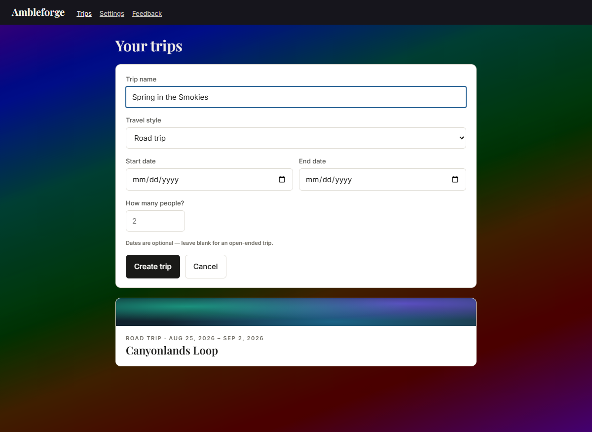
The new-trip form: a name is the only required field; style, dates, and party size are optional
A name is all it takes. Travel style, dates, and how many of you are going are right there if you want them — the whole-trip cost divides itself per person from that number.
02 · The trip at a glance
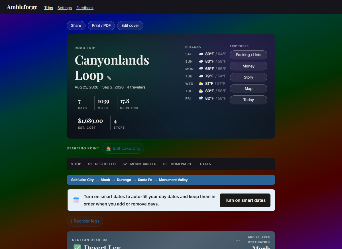
Trip overview: hero with stats and a 7-day forecast, starting point, route bar, and colored section headers
Days, miles, drive hours, and cost roll up live. The 7-day forecast follows your itinerary — before the trip it watches your first stop; once you're rolling it shows the weather where the plan says you are today.
03 · One form builds the day
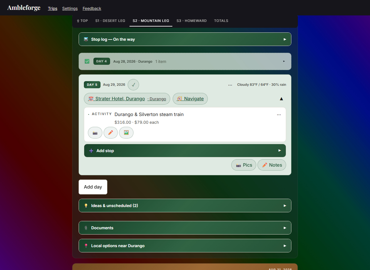
The Mountain Leg open: Travel info, forecast and Stop log drawers, a done day folded to one line, and today's card with the steam train — $316.00 · $79.00 each — with photo and note buttons
Set where you're staying — date, hotel, address (with type-ahead), nightly rate — and day one assembles itself: the city, its weather, and the drive from your last stop, fetched automatically the moment you save. Even the currency matches the country the address is in. And money reads the honest way on every stop: the share each person actually owes, right on the card.
04 · Browse what's nearby
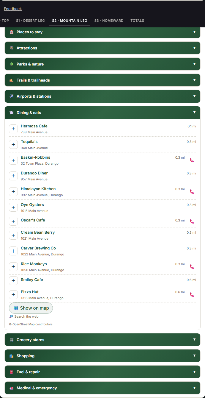
The local-options drawer near Durango: ten categories including Fuel and repair and Medical and emergency, each option showing its address and a tap-to-call number, distances measured from the hotel
One drawer per stop, ten categories deep: places to stay, attractions (casinos, museums, landmarks), parks & nature, trails & trailheads (hiking, biking, horseback, motorized), airports & stations, dining, groceries, shopping — and, for the road itself, Fuel & repair and Medical & emergency. Every distance is measured from your hotel's door, not the town center; where the map has it, each place carries its address and a one-tap phone number. Pick your search distance — 5 to 50 miles — and pin any category's results on your trip map, ready to add to the day with one tap. A Travel info drawer rounds it out with the state's official road-conditions (511) and tourism sites — verified links, all 50 states + DC — plus the destination’s own official website (worldwide) and short traveler notes from Wikivoyage. Open that drawer once while you have signal and it keeps for a month, ready to read offline — it is the one part of a stop that waits for you rather than saving itself.
05 · Add stops with one tap
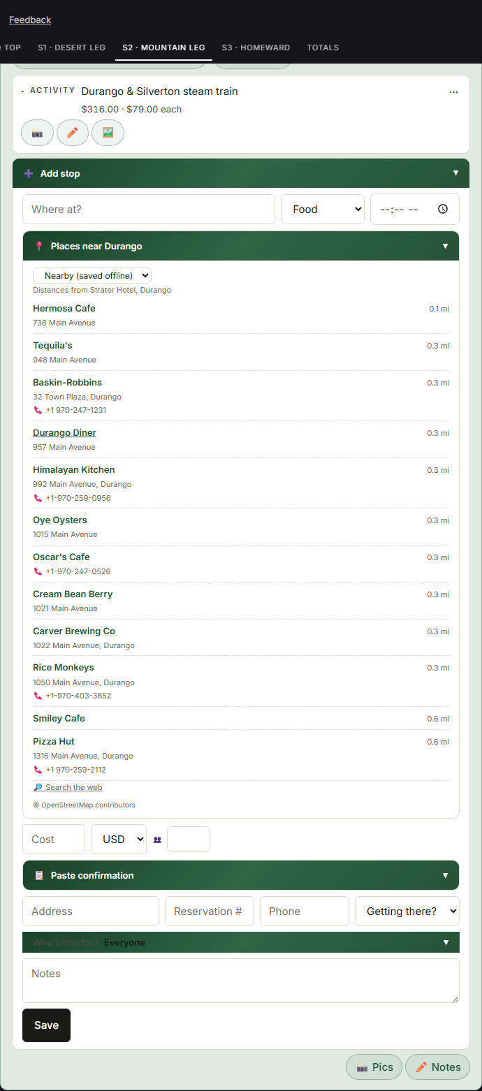
The Add-stop drawer with Food selected: the nearby dining list with a Within-10-mi picker, paging, paste-from-confirmation drawer, and the Who's-this-for chips
The add form lives in a tidy drawer that opens when you need it. Choose Food and the dining list opens with it — pick your reach, 5 to 50 miles, and one tap fills the name and address. Paste a confirmation email or text and the form fills itself in. And "Who's this for?" handles the days the group splits up — Everyone is the one-tap default.

Travel it

On the road, with or without signal — the plan keeps up with you.

01 · See the whole journey
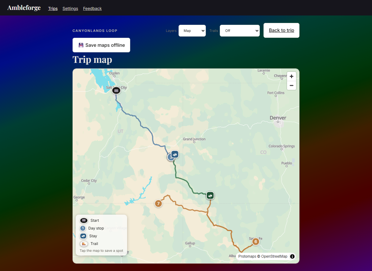
The trip map: numbered day pins with the driven route following the real highways between them, each leg colored to match its section — blue to Moab, green to Durango, amber home through Santa Fe
Every stop pinned in its section's color — and the route between them is the roads you'll actually drive, not straight lines over the mountains, each leg colored to match its leg of the trip. Switch layers — street, topo, satellite — paint trail networks by travel mode, and tap anywhere to save a spot straight into your ideas. And with one tap, save the trip's maps for offline — free: the whole region in overview plus street-level detail along your route and around every stop, rendering in airplane mode like everything else — the real route included. Street tiles come from our own map server — no tracking, no per-view fees, no caching restrictions.
02 · Today mode
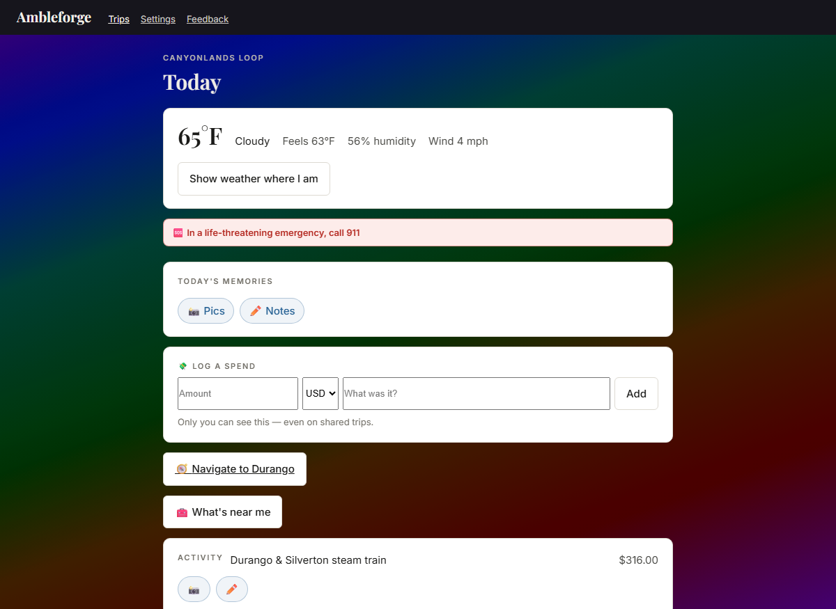
Today mode: current weather, the emergency number, Pics and Notes capture, a private Log-a-spend, navigation, and today's plan
Built for the passenger seat: right-now weather, today's plan, tonight's stay, one tap to navigate — all readable in glare, one-handed, with zero signal. Pics and Notes sit right there for the day and for every stop, and a private Log a spend rides along that nobody else on the trip can see.
03 · Done as you go
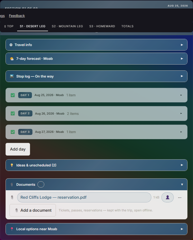
A completed section: check-marked header, past days collapsed into dimmed summary rows
As dates pass, days fold themselves into tidy checked summaries and finished legs wear a ✓ — automatically, computed from the calendar, so it works offline and flips at midnight. Tap anything to reopen it; mark items or whole days done by hand whenever you like.
04 · Pocket the paperwork
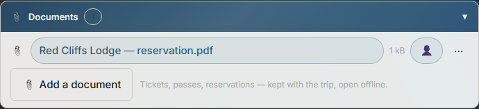
A section's Documents area holding a reservation PDF that opens offline
Tickets, passes, reservations — saved into the trip itself, per section so nothing gets mixed up, and they open with zero signal in the middle of nowhere.
05 · When the car — or someone — needs help
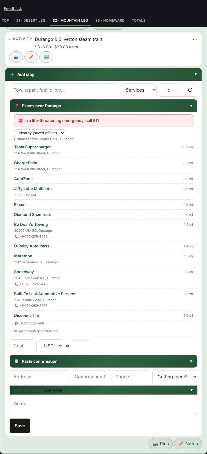
Adding a Services stop: the nearby list shows fuel, charging, towing and repair options around Durango with addresses and tap-to-call numbers, topped by a red emergency notice naming the local emergency number
Add a Services stop and the nearby list turns to fuel, tires, and repair around you — with addresses and one-tap numbers to call ahead. A separate Medical & emergency list covers clinics, pharmacies, police, and fire. And because we're honest about what this app is, a plain notice sits on top with the emergency number that works where you are — 911 here, 112 in Europe, the right one in 233 countries — Ambleforge helps you find help, it isn't the help.

Do it together

Trips are a team sport. The whole family plans, packs, and edits the same trip — live.

01 · Share the trip
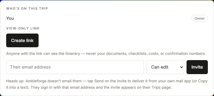
The share panel: the view-only link with Copy, New link and Turn off, the off-by-default Also-share-the-Story switch, and the email invite form with a role picker
Invite anyone by email as an editor, a viewer, or "Can add memories" — the kids-and-grandparents role that can see everything live and add photos and notes, but can't touch the plan or the money. They accept from their own Trips page and the same trip appears on their phone — edits sync live in both directions, and permissions are enforced at the database, not just the buttons.
02 · Before you go
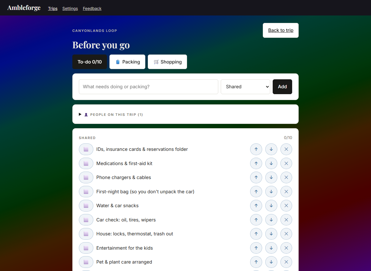
The Shopping list tab active beside To-do and Packing, seeded with road-trip basics — bottled water, snacks, coffee, ice for the cooler
Pre-trip planning built for a family: three lists on one page — to-dos, packing, and a shopping list for the aisle — and every row belongs to Shared or to a person, with per-person progress, so whoever's herding the crew sees who's ready at a glance. A starter list seeds the obvious; make it yours from there.

Remember it

The trip doesn't end when you get home — it becomes a book.

01 · The cover
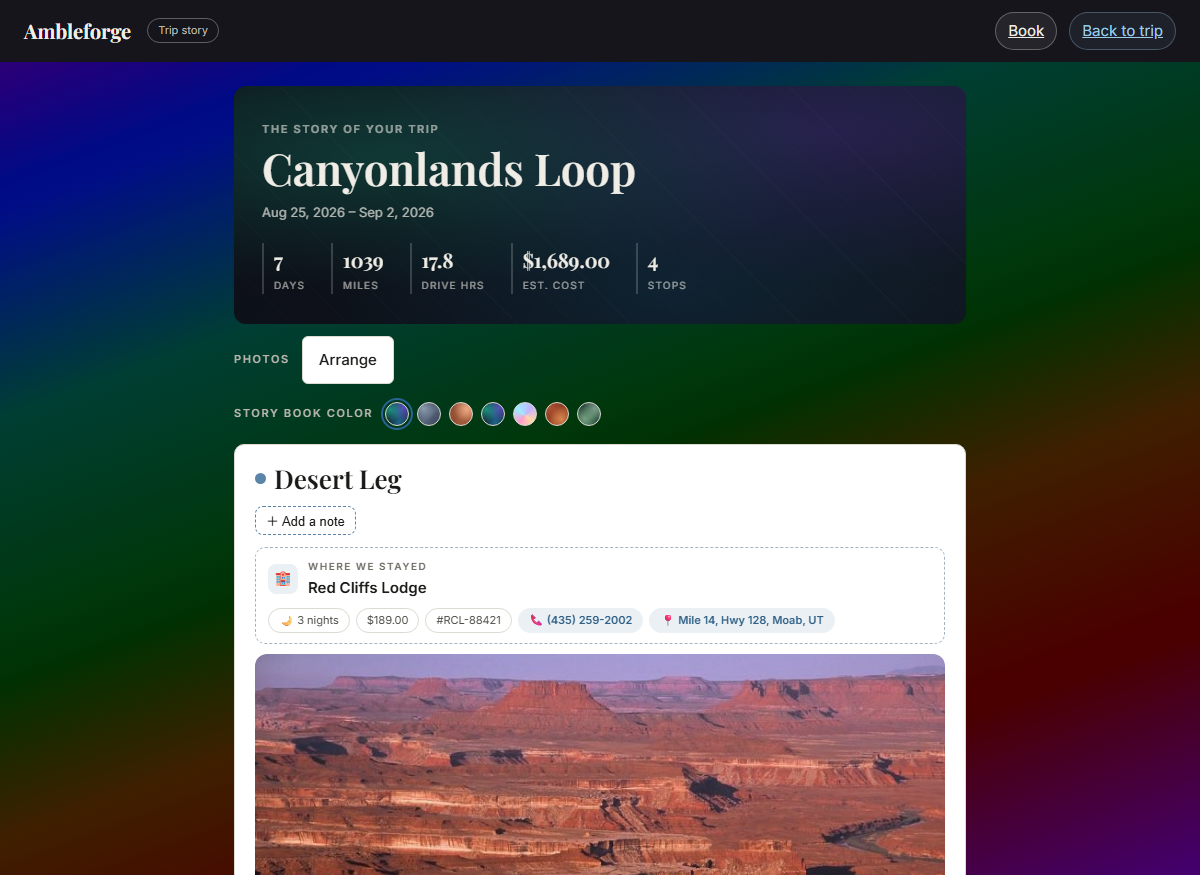
The Story's cover page: trip title over the trip's cover colors, with live stats — 7 days, 1039 miles, 17.8 drive hours, estimated cost, 4 stops — a Story book color picker, and the first leg opening on a photo from the trip
Your trip, told back as a keepsake. The Story opens on a cover that inherits the trip's look and its real numbers — days, miles, drive hours, cost, stops — and a Story book color dresses the book without touching the planner.
02 · Caught at the stop
Today mode's capture row: Pics and Notes on the day, the private Log-a-spend, and the steam-train stop carrying its own photo and note buttons
The book writes itself while you travel. Pics and Notes sit on the day and on every stop — the hike, the diner, tonight's stay — about ten seconds each, zero signal needed. A photo taken at the steam train lands in the Story under the steam train, not in a pile at the bottom of the day.
03 · A leg, told back
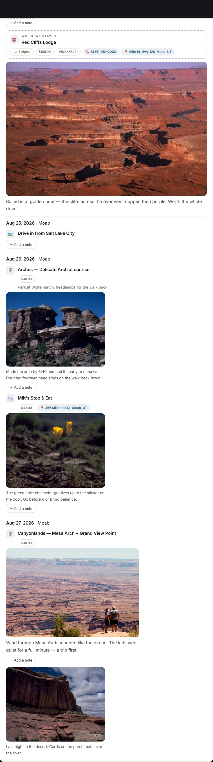
The Desert Leg in the Story: the stay card with its details, then day by day — the drive in, Delicate Arch at sunrise — each with the memory written at that stop
Each leg opens with where you stayed, then threads the days — what you did, what it cost, and the moments you caught at each stop, right where they happened. Every stretch of text is editable, so it reads like the day actually went. And one switch on your share link lets grandma read it too — the memories, never the paperwork.
04 · Your actual printed pages
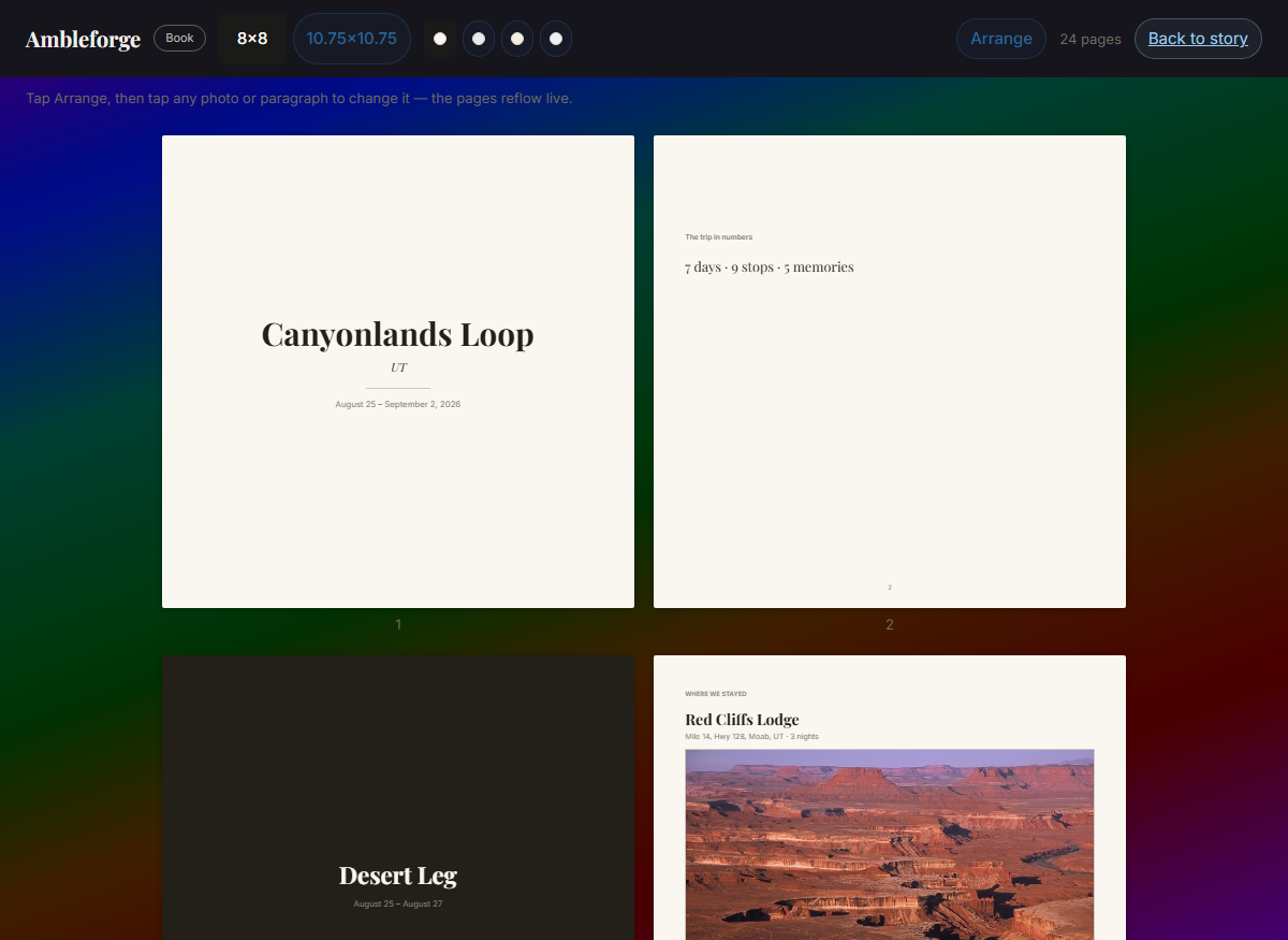
The Book view: the trip's story laid out as printed pages — a title page carrying the trip in numbers and everyone who came, a leg's title page, and the stay page — with a page count and size and page-colour choices in the top bar
Open your story as the book itself — not a preview, the actual pages, with the same page breaks, photo placements and words a printed copy would have. Choose the size and the page colour and the pages re-flow as you watch. It looks the same on a phone as it does on a laptop, because the layout is worked out from your trip and the type, never from the screen you happen to be holding.
05 · Arrange it your way
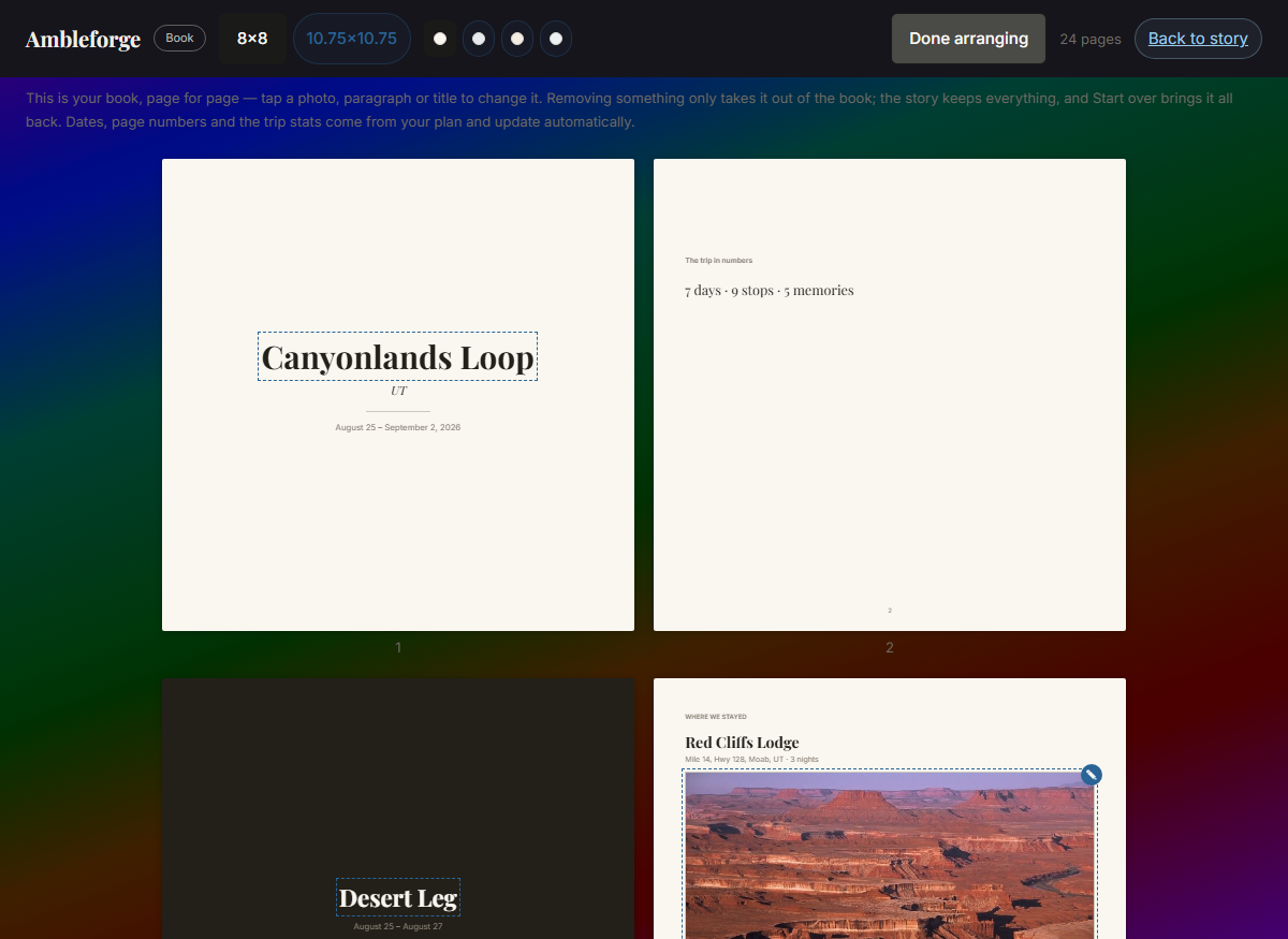
The Book view with Arrange turned on: every photo and paragraph that can be changed is highlighted on the page
Tap Arrange and everything you can change lights up, right on the page: move a photo earlier or later, resize it, fix a caption, rename the trip, a leg or a stop, and correct anyone’s name in the crew or put the names in the order your family reads (the name carries through the whole trip; the order belongs to the book). When you order, you get an email confirming what you bought and where it’s going, and another once the printer has it — then we print it, bind it and post it to you. Leave something out and it goes from the book only — your story keeps every word and every picture, and Start over brings the whole lot back. Nothing you took out is ever thrown away.

Everything a trip needs

High-tech under the hood, simple in your hand — and nothing held hostage behind a paywall. Four groups; tap one to open it.

Plan it fast

The busywork does itself — you just make the decisions.

Day-by-day builder

Sections, days, stays, activities, notes — arranged in the order you'll live them, each with its time and one-tap "getting there" chips: directions driving, walking, by transit, or a ride, measured from your stay. The trip divides into named legs, each with its own color; opening one closes the one you just finished, days fold to a scannable top line — number, date, drive, weather, where you're staying — and stops collapse the same way, name and time on one line, so a two-week leg reads as a list you can scan instead of a scroll you have to swim through. Ideas that don't have a day yet wait in their own drawer, ready to deal onto any day in a tap. And a trip can lead with the style that fits it — road trip, slow travel, group, transit — presets over the same trip, never separate apps.

Dates that flow

Set a start date and the days fall into line — add a night and everything after it shifts a day, automatically. Booked a flight or a non-refundable hotel? Pin it, and the plan flows around that fixed point instead of dragging it. Reorder days — or whole legs — in a tap-safe mode and watch the dates re-flow live. And if a booked stay falls out of step with the plan, the app says so until you've updated the reservation. It's built for tired thumbs, too: each card keeps its actions behind a ⋯ menu in its top corner, and nothing goes without asking.

A mis-tap is never a disaster

Deleting anything — a stop, a whole day with everything on it, the stay, a photo, a note — takes two taps, then offers a six-second Undo that really does bring it back, pictures and all. Miss that too? Every trip has Recently deleted at the bottom, holding the last 30 days of everything you removed — restore a day and its stops come back with it. Three layers, because the thing you delete by accident at a rest stop is usually the thing you most wanted to keep.

Reservation slips

Lodging cards with confirmation numbers, addresses, check-in and check-out times, and one-tap directions. Paste a confirmation email — or a confirmation text message — and the form fills itself in — name, phone, address, confirmation number, nights, times, people, even the total price divided into your per-night cost — right on your device, filling only the blanks. You see what it found first as little tags and can tap off anything before it fills, and the same paste works on dining and activities too. A booking's added insurance — travel protection, damage cover, a weather guarantee — takes one summed 🛡️ line instead of crowding the card, and counts toward the budget and the settle-up like everything else. Changed hotels mid-leg? Add the new place as a lodging stop on the day you move: from that day on it's the stay that shows, the point "getting there" measures from, and where the nearby distances follow you.

Head home fills itself in

One tap adds the drive home: the new leg starts pointed at the place your trip started from, with the miles and the drive time already worked out from your last stop. The last day of a trip is the one nobody feels like planning.

Drives, done for you

Times and miles fill in between stops; navigation hands off to the maps app you already use. Not driving a leg? Mark it fly, train, bus, ferry — the trip default is yours to set, and any day can differ.

Stops on the way

Road trips are mostly the bit between the places. Add lunch, fuel, or a viewpoint straight to the "On the way" log — name it, say what it's for, done — and it sits above the day's plan in the order you'll actually reach it: add somewhere from the nearby list to a day you're driving to and we work out where on that drive it falls, so your stops keep road order rather than the order you thought of them. You can also just browse what's on the road ahead — fuel, food, viewpoints, parks — straight from the maps saved with your trip, so it works with no signal. Take a photo or jot a note at any of them and it lands in your trip's Story under that stop. Reorder arrows live in their own "Reorder stops" mode rather than on every card, so reaching for Edit can never nudge your day out of order.

What's nearby

Ten categories around every stop — stays, attractions, parks & nature, trails, transit, dining, groceries, shopping, plus fuel & repair and medical & emergency. Distances measure from where you're staying, addresses and tap-to-call numbers ride along where the map has them, and one tap drops a find straight into your plan. Pick your reach — within 5 to 50 miles, remembered per trip — and page through the results twenty at a time ("21–40 of 58 within 20 mi") instead of squinting at one long list. "Show on map" pins the results on your trip's own map — tap a pin for the address, phone, and distance, and add it to the day from right there. And when open map data runs thin, a one-tap web search picks up the slack.

Travel info, from official sources

Every leg carries a Travel info drawer with the links that matter on the road: the state's official road-conditions (511) and tourism sites — all 50 states + DC, every link machine-verified — plus the destination's own official website (the city's, the park's), found automatically, worldwide. Short traveler notes round it out — how to get in, get around, and stay safe, a few honest sentences from the free Wikivoyage travel guide with credit and read-more links. Everything opens outside the app (we surface, they inform). Unlike the nearby lists, which save themselves, this drawer fetches when you first open it — do that once per destination before you leave signal and it is yours to read on the road for a month.

Weather where you're going

A 7-day outlook on every destination, current conditions where you stand — and for trip days months out, what it's typically like, from ten years of records.

Ready for anywhere

Off-grid is the design target, not an afterthought.

Works with zero signal

The whole plan lives on your phone. Edit it in a canyon; it syncs when you're back. Live extras — weather, nearby results — fetch when you're online, keep their timestamp, and show honestly dated when you're not: never a spinner, never a blank space, never load-bearing for the trip itself.

The whole journey, mapped

Street, topo, and satellite layers; trail networks by travel mode — hiking to horseback to off-road; every stop and stay pinned along your route. One tap saves the maps your trip actually needs — the whole region at overview zooms, plus street-level detail along your driving route and around every stop — so the map still answers in a dead zone. Free forever: paywalled offline maps break trips, so we don't.

Everything one tap from the trip

Trip tools sits beside the forecast on every trip: Packing / Lists, Money, Story, Map and Today, as five plain buttons rather than a row of icons you have to decode. And the "where you're staying" line on any day opens turn-by-turn navigation to the property from wherever you are — the thing you actually want at 9pm on the last hour of a drive.

Today mode

One glance at the day you're living: what's happening, the drive ahead, what's nearby, and — on travel days — everyone's arrivals by person. Drive days lead with your on-the-way stops in road order, a quick capture button drops a photo or a line onto any stop as it happens, and the shopping list is one tap away because that's the screen already open at the till. Works with zero signal, like everything else.

A pocket for the paperwork

Tickets, passes, and reservations attach to the leg they belong to and store inside the trip itself, so a gate agent's "can I see it?" works in airplane mode. They fold into their own drawer with a count, so a leg with nine attachments still reads as one line until you want them. Rename anything — a camera's "178699444….jpg" becomes "Damage protection receipt" — and long names shorten politely instead of shoving the row off the screen. Photos downscale on your device before upload; documents ride along in the trip export.

Roadside & ready

When the car needs fuel, a tire, or a mechanic — or someone needs a clinic or pharmacy — the nearby list has a lane for it, with one-tap numbers to call ahead. It's saved to your phone along your entire route — every stop, and the highway between them, every ~11 miles — so "What's near me" in Today mode finds the nearest gas station from your live GPS position even at mile 150 with zero signal. Honest by design: a plain emergency notice rides along with the number that actually works where you are — 911 in North America, 112 across Europe, the right one in 233 countries, saved offline like everything else — because this helps you find help; it isn't an emergency service.

Done as you go

Past days check themselves off and fold away automatically — computed from the calendar, so it works offline. Finished legs wear their ✓; anything reopens with a tap.

Memories, as they happen

Snap a photo or jot one line on any day — about ten seconds, even with zero signal (it syncs when you're back). Every stop is its own memory spot: tonight's stay, that hike, that dinner each take their own photos and notes, so the room's pictures stay with the room — and day-level moments (morning light, scenery) keep their own place. A photo that landed in the wrong spot has a "file under" mover, and the stay's card collects the whole leg's album, any night. Forgot to shoot through the app? The camera button asks which you want — Take a pic or Gallery — so the day’s photos come straight from your phone’s own library, several at once, one memory each. And a caption is never locked in: tap the words under any photo to rewrite them, or "Add a caption" under one that hasn’t got any — batch-added pics included. Memories live inside the trip, stay private from shared links, and store at print quality.

Your trip, told back

The Story is your trip as a keepsake scroll: it opens on a cover page that inherits the trip's cover and its live stats — days, miles, cost, stops — then each leg tells where you stayed, the weather those days, what you did, where you ate, and the memories you caught at each, with every stretch of text editable so it reads like the day actually went. It even narrates the drive — "On the way to Moab we stopped for coffee and a view" — with those stops in road order and a line of your own after each. A leg joins the Story the moment it has a stay, an activity, or a memory; a "Story book color" dresses the keepsake separately from the planner; and the whole thing sits behind a quiet 📖 link on the trip. Private to your travelers unless you choose otherwise. And when you want to see it as a book, the Book view lays the same story out as real printed pages — actual page breaks, actual placements, a page count — opening on a single title page that carries the trip in numbers and everyone who came, in two sizes and four page colours, identical on a phone and a laptop because the layout comes from your trip and the type, not from your screen. Arrange it your way: tap Arrange and move each photo where you want it, at the size you want it — small, half, large or full width. Two half-size photos pair up on a row; a full-width one takes the page. What you arrange is what you get: the same layout on a phone, on a computer, on the story you share, and on paper.

Better together

One trip, everyone's hands on it — and the money stays friendly.

Plan together

Invite family by email as editors, viewers — or "Can add memories": perfect for kids with phones (and grandparents), who see the whole trip live and add photos and notes of their own, but can't change the plan or the money. Everyone works on the same trip from their own phone, with permissions enforced at the database itself, not just the buttons. Invites are delivered by you, not by a robot: each pending invite carries a pre-filled ✉️ Send and a Copy-message button, so the ask arrives in your voice from your own mail app — Ambleforge sends no email.

Before you go

Three lists on one page — to-dos, packing, and a shopping list you can open in the aisle — built for families: assign anything to any person (kids don't need accounts, and kids are marked as kids), watch per-person progress, and start from a sensible template — the shopping list's is the road-trip run (ice, snacks, coffee), not a weekly shop. Every row ticks offline and stays private to your group, and Today mode links straight to the shopping list because that's the screen already open at the till. Type a name once and it's a one-tap choice from then on — here, on tickets, everywhere. And you can name everyone the moment you start the trip: say how many are coming, type their names, mark who’s a kid — and these lists are already theirs before you’ve planned a thing. (Optional, always: skip it and a trip still starts from just a name.) On a stop, “Who’s this for?” stays folded to a single line saying who it’s for — open it only when this one isn’t for everybody. Everyone reads as a family, too: the grown-ups first, then the children they’re responsible for, one household after the next — the same order on every list, every picker and every printout. Set it as you name who’s coming; travelling with another family is one tap away, and a trip that’s just yours never sees the question.

See the trip as any one of you

On the days the group splits up, “See the trip as…” shows the trip through one person’s eyes: their flight, their tickets, the museum only they are going to. Stops nobody was singled out for belong to everyone, so those stay put — only the ones tagged for somebody else step aside, and it tells you how many it tucked away so you are never left wondering whether it did anything. It is a view, never an edit: costs, totals and the plan itself are untouched, so looking at Emma’s day can’t change anyone’s trip. And it only appears once your trip actually has a stop that isn’t for everyone — a control that can’t change your screen shouldn’t be on it.

Costs that add themselves

Every stay and stop totals up live — per day, per section, whole trip. Cross a border and the currency follows — a Canadian hotel prices itself in CAD. Set how many of you there are and every priced card also says what it costs each of you — "≈ $15/person" right beside the price. On the days the group splits up, saying who a stop is for is what sets its count — there's no second number to keep in step. When someone covers a cost as a treat, the per-person figure steps aside: nobody owes a share, so none is quoted. When a cost is split, the card quotes the share each person actually owes — the same number the settle-up uses, not the total divided by heads. Where you're staying reads exactly the same way as the stops around it — usually the biggest number on the trip, so it's the one that most needs to be right.

The trip settles itself

On group trips, any cost can carry who paid and how it splits — everyone evenly, just some people, by shares, exact amounts, or "my treat" for when you pick up the whole tab and nobody owes anybody. The Money page turns it all into where everyone stands and the shortest list of who-pays-who, live, offline, no spreadsheet on the side — and its total flips to Just me to show your own share and what you've paid so far. Kids are never part of the money math — and splitting works for the people who aren't on the app too: say once who pays for a kid or a guest, and their share — down to what they ordered — lands on whoever covers them when you settle up. When you record what things actually cost, the budget view shows planned vs. paid — over or under, per leg and for the whole trip — and settling up uses the real numbers.

Every ticket knows its traveler

When the family converges from different cities, tag each flight, pass, and document with the person it belongs to — including kids and grandparents who don't have accounts; type a name once (or just tap it from your Before-you-go list) and it works everywhere. Kids are visibly kids — 🧒 wherever names appear — and one "People on this trip" list lets you flip kid/adult or remove a name anytime. Tagging stays one tap — "Everyone" is right there as the default rather than something you spell out by picking every name — and a stop the whole family shares reads "Everyone · 6" on the card instead of six names, so a card never outgrows your screen. Then, once some stops belong to a few of you rather than all of you, you can read the trip through one person's eyes: "See the trip as… Sarah" shows her legs and everything shared — the picker stays out of the way until there's something for it to do. On travel days Today mode lists everyone's arrivals by person. Tags print on your itinerary but never show on a public share link.

A spending log that's yours alone

Some spending is nobody's business — and on a shared trip, that should still be true. Jot your own spends (coffee, tolls, souvenirs) right from Today mode as they happen; your personal list and total live on the Money page and ride along in your printed itinerary. Nobody else on the trip can see it — not even the trip owner — because it's stored with your account, not the trip. Group costs and settling up stay completely separate.

Share the plan, keep the private stuff

One link shows your itinerary to anyone — no account needed, on any phone. What the link hands over is one sealed, redacted copy of the plan, not access to the trip itself: your documents, checklists, costs, who-it's-for tags, and confirmation numbers never leave the server. Want grandma to see the photos too? An owner-only switch — off by default — also shares the trip's Story on the same link: the memories and notes, never the documents or the money. A Share… button opens your phone's own share sheet with the link ready to send. Turn the link off anytime, or mint a fresh one and the old link goes dark for good.

Yours to keep

Print it, export it, reuse it, make it look like you.

Beautiful enough to print

Itineraries that read like a well-made travel binder — PDF and paper included.

Lives in your calendar too

Export the whole trip — or a single day — as a calendar file that drops straight into Google, Apple, or Outlook calendars. Days, timed plans in the right time zone — set the time right on any activity or dinner card — and hotels spanning check-in to check-out, with confirmation numbers along for the ride.

Take everything with you

One tap saves your whole trip to a single file on your device — every leg, day, and stop, notes, checklists, people, memories, story text, your own private spending log, even your uploaded documents and photos, all inside it. It's an open, machine-readable format (JSON), so your trips are readable by you and by other software, forever — with or without us. Works offline on a synced device.

Plan it again

Duplicate any trip in one tap — the whole structure comes along, ready to reuse. Pick a new start date and every day falls into place. Last summer's loop becomes this summer's plan in about a minute. Any member can do it, even a viewer: the copy is theirs alone, private, with the done-marks reset — a trip a friend planned becomes the starting point for yours.

Make it yours

Seven color palettes (metallic to pastel to black & white), four card styles (paper, flat, frosted glass, soft), aurora backdrops, dark mode, text size, miles or kilometers, 12-hour or 24-hour time — set per device, so each family member reads the trip their way. The trip itself dresses up too: a curated cover, a metallic color identity per leg, even one of your own photos behind a leg's header — and if a co-traveler recolors the trip, that's their view alone, saved with their account so it follows them across devices while yours stays yours. Bold, but never unreadable. Any stop card can wear one of your own photos as its background too — the hotel, the diner, the trailhead — just press and hold a pic in the card's gallery and choose "Make card background", then drag and zoom across the whole card to frame it, always readable over the top.

Readable by everyone

The whole app works by keyboard, carries proper labels for screen readers, and keeps WCAG AA contrast on every screen — big type stays big, focus is always visible, and "Skip to main content" is the first Tab stop. Checked by an automated accessibility test before every release, not by good intentions.

How it works

Five steps. The first one is just typing a name.

Name your trip.

That's genuinely all it takes to start — dates, travel style, and party size if you want them.

Set where you're staying.

One form per leg: arrival date, hotel, address with type-ahead. Day one builds itself — city, weather, and the drive from your last stop fills in on its own.

Fill the days.

Activities, meals, and stops picked straight from what's nearby — or saved as ideas from the map and dealt onto days later, one tap each.

Bring the family.

Invite everyone by email, plan the same trip together live, and divvy up the packing in Before you go — it's under Trip tools → Packing / Lists.

Hit the road.

Today mode shows what matters right now — no signal required. Days check themselves off as you travel. Sync happens by itself.

The honest part

Most travel apps make their money in ways they'd rather not explain. Here's exactly where we stand — in writing. Seven promises; tap one to open it.

Free means a whole trip

No stop limits, no trip limits — a promise, not a trial.

Plan a complete trip free — no stop limits, no trip limits. The free plan handles a real family's year of travel, start to finish. That's a promise, not a trial.

Paid will mean extras, never basics

Nothing you can do today will ever move behind it.

A paid tier is coming for the nice-to-haves. Nothing you can do today will ever move behind it — planning, offline, sharing, and collaboration stay free.

No billing tricks

Cancel in the app, a monthly option always offered, no traps.

When paid arrives: a monthly option always offered, cancel right in the app, no silent upgrades, no annual-only traps. If a subscription needs a dark pattern to survive, it doesn't deserve to.

No ads. No data selling.

You are the customer, not the product.

You are the customer, not the product. We don't run ads, we don't sell or share your data for advertising, and our maps come from our own server — no tracking pixels riding along. The only thing we measure is our own tally of how the app gets used — how many trips and stops you've added, whether you were offline — never your trip titles, places, notes or photos, and never through anybody else's analytics service. It's stored on your own account, deleted with it, and there's a switch in Settings.

Deleted means deleted

Erased from our servers — photos and all — within about 30 days.

Delete a trip and it's permanently erased — photos and all — within about 30 days. That window is your safety net to change your mind; after it, it's gone from our servers for good.

Your trips are yours

If you ever leave, you leave with everything.

Print them, export them to your calendar, download them whole — documents and photos included — as one open file, share them with a link. Your data is never held hostage: if you ever leave, you leave with everything.

Protected by design

Enforced by the database itself on every request — not by buttons in the app.

Who can see and change what is enforced by the database itself on every request — not by buttons in the app. What a share-link visitor's device receives is redacted on our side of the wire: costs, confirmation numbers, and who's-this-for tags simply never leave the server. A link hands over one sealed copy of the itinerary rather than access to the trip itself — there is nothing else on it to reach for. Trip invites only open for a confirmed email address. Traffic is encrypted in transit. Photos you capture are re-encoded on your own device before upload, which strips hidden metadata like GPS location. Maps come from our own servers with no tracking pixels, error reports never include your identity or your trip's contents — and you can delete your account, and everything in it, right in the app.

Put it on your phone

No app store, no download wait — Ambleforge installs straight from the browser and then behaves like any other app: its own icon, full screen, works offline, updates itself.

iPhone & iPad

Open the app link in Safari, tap the Share button (the square with the arrow), scroll down, and choose Add to Home Screen, then Add.

Android

Open the app link in Chrome, tap the ⋮ menu, and choose Add to Home screen (some phones say Install app), then confirm.

Computer

It works right in the browser — nothing to install. In Chrome or Edge you can also click the install icon at the end of the address bar to give it its own window.

Getting ready for no signal

Three things, about a minute between them — and the honest caveat nobody else will tell you.

Before you drive out of coverage

What to do, what you can ignore, and what your browser is actually doing with your trip.

01 · The whole checklist
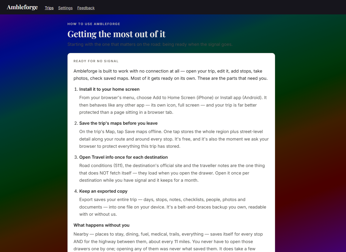
Ambleforge's How to use page, open on Ready for no signal: three numbered steps — install it to your home screen, save the trip's maps before you leave, keep an exported copy — followed by an honest caveat about browsers reclaiming space, and a line reporting whether this device's browser has granted protected storage
Install it to your home screen, save the trip’s maps, open Travel info once for each destination, and keep an exported copy. That is the whole list — and it is short because most of it is already done for you (next drawer). The app carries the same checklist at Settings → Ready for no signal, which also tells you whether your browser has agreed to protect this trip’s data on your device rather than leaving you to guess.
02 · What saves itself

You do not have to open the nearby drawers one by one. Places to stay, dining, fuel & repair, medical, trails, groceries — every category — saves itself for every stop on the trip and for the highway between them, roughly every 11 miles, from the moment the trip has places in it. Opening a drawer was never what saved it; one fetch per location brings down all ten categories at once. It is unhurried on purpose, so on a long trip give it a few minutes with the app open on wi-fi after you finish planning — there is no progress bar, and this is the only reason to wait around.

03 · The honest caveat

Browsers reclaim space from sites you haven’t opened in a while — on iPhone that can be after roughly a week untouched, and it applies to every web app, not just this one. We do the one thing the web allows about it: when you save a trip’s maps we ask your browser to mark this trip’s data as protected. Asking is not the same as being granted, and we’d rather say so than imply a guarantee we can’t give. So: install it, save your maps, keep an exported copy — and if your trip is weeks away, open it now and again. If you’re leaving next week, there’s nothing to do at all.

04 · Advice you can ignore

General “offline web app” tips get repeated a lot and don’t apply here. You don’t need to keep a browser tab open — close it whenever you like; installing to your home screen is what actually helps. You don’t need to open every day, or every nearby drawer, to force a download — your whole trip is already on your device the moment it syncs, the nearby lists save themselves along your whole route, and maps are one deliberate tap. The single exception is the Travel info drawer, which is why it is on the checklist above. And you don’t need to wonder whether there’s an export: there is, it includes your photos and documents, and the file is yours to keep.

Questions, answered straight

Does it really work with no signal?

Yes — and not just reading. Ambleforge is the only trip planner where everything works offline: open your whole trip, edit it, add stops, jot notes, snap memories, check tomorrow's cached weather, even browse your saved maps and find the nearest fuel along your route — all in airplane mode, all on the free plan. Changes sync themselves the moment you're back in coverage. We prove this before every release with an automated airplane-mode test of the entire app.

Do I need to do anything before I lose signal?

Four things, and they take about a minute: install Ambleforge to your home screen, save the trip’s maps from the Map page, open the Travel info drawer once for each destination (the one part of a stop that doesn’t fetch itself), and keep an exported copy of the trip on your device. The nearby lists — food, fuel, lodging, medical — need nothing from you at all: they save themselves for every stop and for the road between them, so give the app a few minutes on wi-fi once the trip is planned. You do not need to keep a browser tab open, and you don’t need to open every day to “force a download” — that advice gets repeated about web apps generally and isn’t how this one works. The honest caveat: browsers reclaim space from sites you haven’t opened in a while, so if your trip is weeks off, open it now and again. The app spells all of this out in Settings → Ready for no signal, including whether your browser has actually granted protected storage on your device.

What does it cost?

The free plan plans a complete real trip — no stop limits, no trip limits, offline included. A paid tier will come later for extras, and the basics will never move behind it. No ads either way, ever.

Does it work on my phone?

iPhone, Android, and any computer — Ambleforge installs straight from the browser (instructions above) and behaves like a native app: its own icon, full screen, works offline, updates itself. App-store listings are planned; you don't have to wait for them.

Does it work outside the US?

Plan a trip anywhere. Cross a border and the currency follows — a Canadian hotel prices itself in CAD; the destination's own official website is found automatically worldwide; and the emergency notice names the number that actually works where you are, in 233 countries. We're honest about the edges: the official road-conditions (511) links are a US thing (all 50 states + DC), and our own map server's street-level detail covers the lower 48, Alaska, Hawaiʻi, Puerto Rico, and the near border regions of Canada and Mexico — elsewhere the map uses standard online layers, which you can still save for offline.

Do my kids need accounts?

No — and there are two comfortable levels. Without an account, people are just names: type "Emma" once and she's a one-tap choice everywhere — packing lists, to-dos, her tickets, even a "See the trip as… Emma" view once the trip has stops that aren't for everyone; mark her as a kid and she's visibly a kid wherever names appear (and never part of any cost splitting). And if she's 13 or older with her own phone, you can — with your consent as her parent — set her up with an account and invite her as "Can add memories": she sees the trip live and adds her own photos and notes, but can't change the plan and never sees the trip's money. If she was already a name on your lists, her account becomes that same person — no duplicates. (Under 13, kids stay as names — you add their photos from your own account.)

Can grandma follow along without installing anything?

Yes — share one link and she sees the itinerary on any phone, no account needed. What the link carries is a sealed, redacted copy of the plan — your documents, costs, checklists, and confirmation numbers never leave the server. If you want her to see the trip's Story too — the photos and notes — that's a separate switch on the link, off until you flip it, and it still shares only the memories, never the paperwork or the money. Turn the link off anytime.

What happens to my data?

It's yours. We don't sell it, we don't run ads on it, and there's no third-party analytics service or tracking pixel anywhere — the only measuring is our own anonymous tally of how the app gets used, and Settings → Privacy has a switch that turns even that off on the spot. When you delete a trip it's permanently erased — photos included — within about 30 days, and you can delete your whole account, and everything in it, right in the app. The full privacy policy is written in plain language, linked below.

Can I get my trip out of the app?

Always. Print it as a travel-binder-quality itinerary, export the whole trip (or one day) to Google, Apple, or Outlook calendars, download the entire trip — documents and photos included — as one open machine-readable file, or share it with a link. Your trips are never locked in.

Where is Ambleforge today?

In family beta — real trips are being planned and travelled on it right now, and it's tested hard before every release. Join the waitlist and you'll be first in line the day it opens.

Be first in line

Ambleforge opens soon. The free plan will handle a real trip, start to finish — no surprise paywalls, ever.

Join the waitlist ↑ Or open the app (beta) →